For Experts
5 hrs
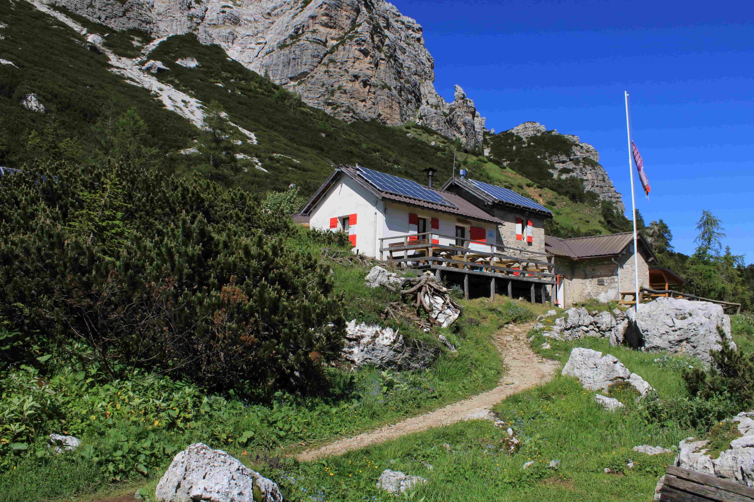
Rifugio Carestiato
Rifugio Sommariva al Pramperét
From Rifugio Carestiato, continue along the small road, first steep to the north and then comfortable to the south and east, which is marked 549. Crossing the beautiful pastures with slight ups and downs, leave the road and take the path to the south-east that goes sharply down towards Passo Duràn, at 1,601 m, which can be reached in about 45 minutes from the Rifugio Carestiato. Right on the pass, therefore on State Road 347, stands the Rifugio Passo Duràn "Cesare Tomè". Open from the beginning of June to the end of September and on holidays in May and October, the mountain hut offers 22 beds and a small hotel service with local menus. Electric lighting available. Wi-Fi connection available. Toilets and showers are available. Mountain hut telephone number: +39 3464165461 / +39 3481030648. Website: www.rifugiopassoduran.it. Email: [email protected] [email protected] Near the pass you’ll also find the privately owned Rifugio San Sebastiano al Passo Duràn with 25 beds available. Mountain hut telephone number: +39 0437 6 23 60. Email: [email protected] www.passoduran.it. Annual opening (June-end October, 8 December-6 January, every weekend until June). From Passo Duràn, take State Road 347 southwards, i.e. towards Agordino, for just over a kilometre and a half to the wide bend in the road at Ponte sul Ru de Càleda, about 1,500 m, 20 minutes from the pass. High above looms the towering and impressive Sass de Càleda. Leave State Road 347 and take path 543 to the south, which soon climbs to Forcella Dagarèi, at 1,620 m, from where the path continues south-eastwards at an average altitude of between 1,600 and 1,700 metres. Below the Tàmer Grande is path 594 that climbs from the Casèra de la Róva. Continue on path 543, which now heads south and climbs moderately until it meets path 544 at an altitude of around 1,770 metres, which also comes from the Casèra de la Róva. Keep to path 543 which, in a south-easterly direction, passes the junction of path 542 of the Valle Ru and goes as far as the Malga (or Casèra) del Moschesìn, at 1,800 metres (a discrete foothold in case of need) and then, uphill, the Forcella del Moschesìn, at 1,940 m, which overlooks the rugged Val Prampèr, remains of barracks. 4 hours from Rifugio Carestiato. Descending from the pass, after a few zigzags, take the Sentiero de le Balanzòle to the right (east), which runs below the peak of the same name, at the edge of the scree, with slight ups and downs, until you reach the wide meadowy plateau of Pra de la Vedova and the romantic Rifugio Sommariva at Pramperét, at 1,857 metres. 5 hours from Rifugio Carestiato. The Rifugio Sommariva at Pramperét is owned by the Oderzo Section of the CAI and the first structure dates back to 1923, renovated in 1995. The place of serene beauty, the friendliness of the manager, and the good food make this mountain hut a place to remember. Open from 20 June to 20 September, it offers a hotel service with 25 beds and 5 in the winter room. En-suite bathrooms with indoor shower available. Lighting with generator. CNSAS "118" Rescue Station Mountain hut telephone number: +39 0437 1956153. Email: [email protected] Website: www.rifugiosommarivaalpramperet.it
Rifugio Passo Duràn “Cesare Tomè, Rifugio San Sebastiano al Passo Duràn
The Zoldana option: from the Rifugio Passo Duràn-Tomè to the Rifugio Sommariva to the Pramperét From the Rifugio Carestiato to the Rifugio al Passo Duràn "Cesare Tomè", follow the directions of the ninth stage. From Passo Duràn, descend a little to the north, about 300 metres, on the slope of Val di Zoldo, until you come to a level mule track that branches off to the right (north-east) and bears the sign 536. The mule track leads over the meadow- and forest-covered ridges, crosses a small stream at an altitude of 1,568 m, and immediately afterwards meets path 539 descending into the Zoldano. Stay on path 536 which goes east for a while, then south to the Forcella de le Barance, at 1,688 metres, and, crossing the Van dei Gravinài almost at altitude, zigzags up to the Forcella de le Càure (Goats), at 1,725 metres. From the pass, a short descent is made to the "Valentino Angelini" hut, at 1,680 m, at i Scarselóin. 2 hours and 30 minutes from Passo Duràn-Rifugio Tomè. The "Valentino Angelini" hut is a small, charming wood and masonry building owned by the Val di Zoldo Section of the CAI (Italian Alpine Club), named after the valiant mountaineer and scholar, Giovanni's brother. Built in 1982, it offers 6 beds, serves as an emergency stop and is open permanently. Water is available just a few metres away. For information, please contact the CAI Val di Zoldo Section on +39 0437 7 81 00. Path 536, after a short crossing, descends steeply to the area of sóra 'l Sass de San Bastiàn and, at an altitude of 1,480 m, veers east until it meets path 524 up from Pralongo. Stay to the right, on path 536, which goes towards the northern spur of Petorgnón. After passing the Viàz de l'Ariosto via ledge and exposed rocks, you’ll find yourself beyond the spur and you’ll reach the bottom of a large gully. Go up it for a while and, at an altitude of around 1,600 m, and you’ll come out onto a promontory without any issues. With a few ups and downs, continue north-east and finally east to Forcella Col de Michiel, at 1,491 m, which dominates Val Prampèr, Pian dei Palùi and offers a magnificent panorama of the Spiz di Mezzodì. Beyond the fork, path 536 descends through a narrow gully, then crosses southwards, high above the Masarèi, and joins, at an altitude of 1,480 m, the Val Prampèr white road, marked 523. Follow the dirt road southwards and finally reach the beautiful and highly scenic Casèra (or Malga) Prampèr, at 1,540 m, which offers makeshift shelter. Continue south-east on path 523 along an easy mule track that climbs diagonally up the slopes of Cima Prampèr until it comfortably reaches Pra della Vedova and the Rifugio Sommariva at Pramperét, at 1,857 metres. Approx. 7 hours from the Rifugio Carestiato


Head Office: Loc. Sacus 4, 32043 Cortina d’Ampezzo (BL) – P.I. 00806650255 | Privacy Policy – Cookie Policy
The Cortina Skyline is back!
Starting December 23, 2025, the lift system connecting Tofane, 5 Torri, and Falzarego will be back in operation.
A spectacular journey among the peaks, made possible by the synergy between Servizi Ampezzo S.r.l. and ISTA S.p.A.
Ready to touch the sky?